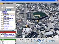
 According to SearchEngineWatch, apparently freeing KeyHole Hi-Res satellite imagery wasn’t enough. Now Google has launched Google Earth, which includes features from Google Local and Google Maps in a smooth, slick interface. At 10MB+, it’s way smaller than I tought (WorldWind goes for a whopping 180 MB) . The basic version is free as in beer, and there’s also a US$20/yr subscription for an enhanced version that supports GPS integration and annotation tools. There’s also a plugin directory that looks… unsettling. In general, it looks good, but as I’ve always suspected Mexico City is still a shapeless blur. Would someone please, please build a functional online Mexico City Map that does not suck?
One thought on “Google Earth is bound to cause a stir”
Comments are closed.
Hi All Experts,
Does anyone use google earth images as ground image planes for use in aerial scenes. I know how to stitch them together but are there any tools or tricks to make sure that the images are at the same height, angle and such to make sure they stitch well. I know in the pro version you can get bigger images but im not going to pay for the pro version when i could stitch multiple images together…